Sunday, January 1

Proposed Camps

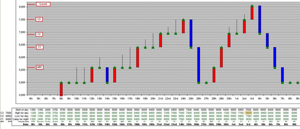
Although I'm going to be independent, I have undertaken a fair amount of research regarding the possibilities of where my camps will be. The picture shoes the latest scenario that I have produced (yes in MS Excel). Many factors will determine this, probably the most important being the weather, but it is important for me to have the correct equipment (tent, food, stove etc) at the right place at the right time. I will also be discussing this further with Jamie once we are at ABC. Due to us having to acclimatise there will be plenty of time for us to chat...

The red bars indicate an ascent with a camp at a higher altitude than the previous night. Camps are demarcated by green triangles. Black lines indicate that a climb occurred to a higher altitude but that I returned to the altitude of the previous nights camp. Blue bars are the opposite of the red bars - going down rather than up.

You might notice that there is a camp at/on the summit - I would like to sleep at 8,000m if I can. This will be a practise run for a high camp on Everest (similar to the South Col). This is a bonus objective and critically depends on how I feel and what the weather forecast is.

Shisha - photo Mike Teger

Advanced Earth Observing Satellite (ADEOS)

Figure depicts the Shishapangma (also known as Gosainthan) and Langtang Mountains in the Himalayas observed by AVNIR. The white sections are mountainous areas covered with snow. The steep mountains seem to cast their own shadows on the tops and the ridges, upper left. This is because the observation time was before noon local time as the sun shone from the lower right.

Nepal is in the lower portion of the figure, and Tibet, China, is in the upper portion, with the complicated border lying in an east-west direction. Shishapangma is on the right of the figure, 8,012 m above sea level on the Tibetan side. You can see other seven-thousand-meter peaks, including Langtang Ri (7,239 m above sea level), Gang Benchhen (7,211 m above sea level), and Langtang Lirung (7,245 m above e sea level). Some glaciers can be seen in the center of the figure near the bottom of Langtang Valley on the Nepal side. Many glaciers line up in the northwestern area around Shishapangma on the Tibetan side. Some glaciers on the Tibetan side have glacial lakes downstream that look copper green or pale emerald green.

The growth and melting of glaciers are considered indices of global warming, and some reports say that glaciers are easily affected by global warming in places at relatively low latitudes and high altitudes, as in the Himalayas and Tibet. As glaciers retreat and contract, glacial lakes collapse, flooding downstream areas and causing a rise in sea level. For this reason, we have to continue careful observation. Valley bottoms less than 1,500 m above sea level (lower left) appear veiled. This could indicate air pollution in the Katmandu basin. The mountainous area and Tibetan Plateau (higher than 3,000 m above sea level) look clear because the thin atmosphere has little influence on visibility.
Greenish brown: Forests
Yellow ocher, brown or gray: Exposed rocks or deserts
Brownish gray or bluish gray : Glaciers
White: snow or ice
Greenish blue or pale emerald green: Glacial lakes
Source: http://www.eorc.jaxa.jp/en/imgdata/topics/2005/tp050719.html

The Plan

Choose between Cho Oyu, 8,201 metres (26,906 feet) and Shishapangma 8,013 metres (26,289 feet). The idea is to be on a mountain, that if I’m feeling good, will present the opportunity to go higher. Who knows, perhaps my body (and mind) might not want to go above 7,000m? But to attempt another 7,000m and find I’m strong with no where else (up) to go, does not seem to be an option to me. I was very interested in Cho Oyu and in fact would have liked to have included a trek (over the Nangpa La pass) from Nepal to its base camp. But that route is still not open and its rumoured that one would be arrested by the Chinese. Jamie (see below) was influencial in me choosing Shisha.

I don’t want to be flown up by helicopter…I want to climb up by myself, just me. It’s not an option to throw a lot of cash at the problem and recreate a “safer” and “easier” route up. Might as well not do it at all, or for that matter might as well watch the Everest Imax movie...
Therefore no Sherpa support on the mountain and no oxygen will be used!
I intend to carry all my camp requirements and build them along the way. I will be using yaks to get my gear from BC to ABC.

I have base camp (BC) and advanced base camp (ABC) infrastructure – mainly food and access to technology. This will be provided by Jamie McGuinness company, Project Himalaya. I did investigate other companies, but immediately felt comfortable with Jamies responses about the level of service he provided. I look forward to meeting him as I feel we will get along well. He will also be organising the infrastructure regarding climbing permits and Chinese permits, transport to BC etc… Something I would like to have potentially done but unfortunately rather difficult while sitting in The Hague. Jamie also offered more free Burger King vouchers for the Base camp outlet than other companies did.

Questions the trip will answer

  • Do I have the organisational skills?
  • Do I have the physical ability to get to & above 8,000m?
  • Is it really all worth it?
  • Is it possible to build a camp infrastructure on my own?
  • What are the affects of the climb on heart rate?
  • Will I be affected by AMS?
  • What rate of ascent is feasible?
  • Is Mount Everest a possibility?
  • Am I able to climb to 8,000m without oxygen?
  • Am I able to climb to 8000, without Sherpa support?

Objectives of 8000m and above

To:

  • Go high
  • Experience the freedom of the hills
  • See the curvature of the earth from land
  • Get to an 8000m summit
  • Sleep above 8000m
  • “Enjoy life” as Mallory said
  • “Dare Mighty Things” as Theodore Roosevelt said